Introduction
The inner city areas (like Null Bazaar, Bora Bazaar, Bhuleshwar, Girgaon) lying within Mumbai have come under a lot of focus today, as there is a wide spread assumption made about them that they are crumbling and are need of immediate rejuvenation. This presents a tremendous opportunity for many as vast acres of land can be tapped for commercial exploitation.Based on this assumption a study is being conducted by a group of us (as planners and architects) to look into the problems of the inner cities and to chalk out master plans that looked at localities as whole to integrate various services like road infrastructure, open spaces, parking, pedestrian movement systems etc. This was also in a large measure to counter the CESS regulation of 33/7 which allows piecemeal development within the inner cities without looking at the sustainability of infrastructure already in place.
However in both cases the key issue of what the new developments would do to the existing systems that were operating on ground is not being taken into consideration or is chosen to be ignored. Both cases flatten, or want to flatten the complex, on site systems of multiple property rights (lease, sub lease, different contracts of tenancies, pagdi, leave and license), and mixed land use to single free hold ownership; And currently there are numerous forces (Rehabilitation programs, builder lobbies, banking institutions) working in over drive to achieve this flattening.
Contrary to this, on-site observations have thrown a plethora of images of what complex systems of ownership have allowed within these localities. Systems of leasing, sub leasing, illegal tenancies have allowed a diverse range of acts and activities possible. People living under staircases, families living across disconnected rooms connected by a shared passages, migrants residing on terraces, printing jobs being carried out for MNC’s in converted dark first floor residences, metal shops storing long strips of aluminum and copper in long shops admeasuring 2m x 20m are just some of the examples that the existing systems and spatial configurations have allowed for. These conditions of multiple tenancies, mixed land usage, time based change of activities have provided number of people access to a source of income and a place to live.
Through out the study we (as architects, engineers) were confronted with crises of our position, our inability to map \ record the above mentioned complexities of the sites and complete helplessness to fathom the nature of development so as to do justice to idea of redevelopment of the precincts. The tools of recording and documentation selected for the study (drawings of landuse, ownership patterns, FSI consumed, building heights, etc) failed to document the softer narratives of people’s lives, their needs, desires and aspirations, as if the tools already had a inherent embedded agenda which allowed and disallowed us from mapping, depending on the applicability of the data.
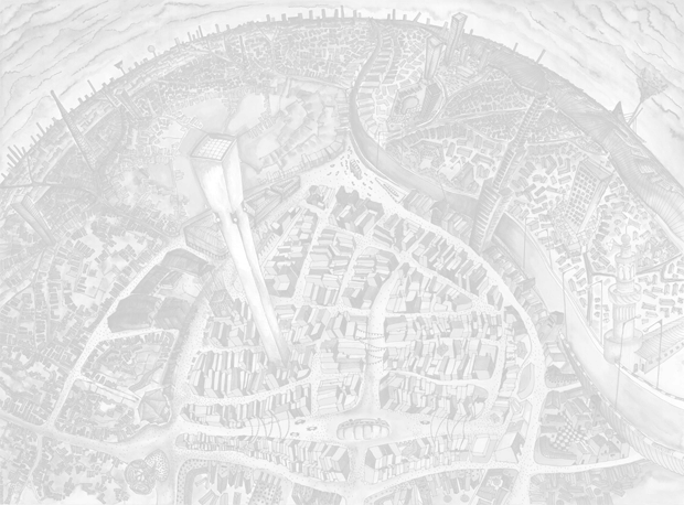
So we decided to look at other more sophisticated mediums that would allow us to map the above mentioned complexities of the site. The medium of constructing images / paintings / graphics (informed by the 3 streams of documentation namely the hard data collected during the project, photographic documentation and household surveys) enabled us to represent these multiple narratives of the site and its people in a more holistic manner. The medium allowed for distortions capable of representing the strange contradictions, unique patterns and peculiar forms of existence, coloured by our own biases and concerns and all those stories that did not find a place in the hard bound data archive we created for rehabilitation of the CESS precincts.
It is a composite project covering urban planning, public culture and visual art. The project has developed some multi-disciplinary maps of localities in Mumbai which represent the multiple narratives of the sites. The cartographic maps are layered with social and cultural observations and visual footnotes, making the works an interface of history and geography.
Madhusree Dutta
Executive Director
Majlis
The team members were recipients of the Majlis Visual Arts Fellowship 2006-07 & this work has been largely possible due to support from Majlis & the Fellowship Program